On two wheels this time. Well 4 in total I suppose. The two amigos are at it again. Last year we ran around Scotland on our motorbikes. Now it is the turn of Ireland to greet these two petrol heads.
Yes, I know I just returned from Ireland in a motorhome with Debbie and Leia dog. But the motorcycle trip was planned before the motorhome trip. The latter being a last minute decision and was simply awesome.
Can a motorcycle trip with this loon match the motorhome trip?
You will have to follow to find out.
The adventure of epic proportions starts on 23rd July and will take 3 weeks. Out and back to Rosslare in SE Ireland encompassing the Wild Atlantic Way, Northern Ireland and down through Central Ireland. The pace is set to allow time to mosey along and take in all the Emerald Isle has to offer.
The motorcycle experience will be completely different to the motorhome journey. Not least that we are doing it in the high tourist season. It had to tie in with my leave from the ship. If any of my dear readers have must do’s then do comment and we will see if we can get to them.
Until my first grand post I shall leave you salivating at whats to come. Ta ta.
The 215 miles drive home was of no real value to thee trip. It was just to get home the quickest way possible, empty the van of all our stuff and give it a brief clean. But what it did do was give us time to reflect on the past month on tour. In no particular order here are our thoughts should you ever choose to do something similar yourself. Here are our 10 tips:
Choose your van carefully. We wanted a permanent bunk so we did not have to worry about making it up every night. Particularly if we were tired or just wanted to go to bed early, or have an afternoon snooze. Ours lifted up to the ceiling of the van and we kept the duvet and pillows on it so it was just a case of lowering it and voila!. The down side was that it was across ways and needed some ladders to get into it even when it was down. Great if you are in your 20s, 30s etc, not 60s. Also to get to the loo one had to crawl over the other to get out. Make sure your van rental company uses Calor gas. It is readily available all over Ireland in supermarkets etc. Our rental company van had Flogas. Disaster. No suppliers in Ireland. Calor gas bottles will fit but you pay more. Also note that UK and Ireland gas bottle fittings differ. We were asked whether we had northern or Southern fittings by a supplier when I phoned them. I did not know. Turns out its northen or southern Ireland and they are different. Choose your van carefully.
The Irish people are simply brilliant. We did not come across anybody who was less than super helpful, friendly and did not want to chat. Sometimes for a long time.
Ireland is a glorious country. But allow plenty of time if exploring the west for the roads can be very narrow, the walls and hedges are high and right on the roadside and the locals drive like they own them. I suppose they do. The quality of the road surface varies from superb new tarmac to terrible. Average speeds therefore are way down on what you might expect.
Ireland is not well served with campsites and motorhome pitches that you may be used to home. We did camp out in the wilds on some nights and that was adorable but you still need to empty the loo tank and fill up with water every three days or so. Places to do so were few unlike New Zealand where facilities are in virtually every town and garage. Be prepared and plan (but not to plan it to death. Allow some freedom). Those campsites we did stay at were well run and by super friendly people. Some were quite basic and others not so. All were clean and well kept. Of note was that in the Irish campsites you are more likely to have to pay extra for showers. Have 1 Euro coins with you.
Even though the roads are as described the volume of traffic is way down on what you may expect at home. Often the roads were deserted unless around the big towns.
If taking a dog into Ireland go via a ferry to Northern Ireland for the roads are seamless crossing the border. In fact you would not know there was a border other than the road signs change from Miles an hour to kilometres an hour and the welcome to Ireland sign. There was no evidence of any checks. We went on the ferry from the UK to Ireland and were directed to Customs as soon as we got off the ferry to clear the dog and check her paperwork. Not even a passport check on us. £220 pounds we paid before we left to have the dog vaccinated, wormed and a health certificate. Kerching! I could be wrong but crossing from Northern Ireland to Ireland and back would have been checkless and free.
Don’t be afraid to start a conversation with people. I even ended up doing an advert for sun cream with a chemist in Ramelton simply because I said we came from New Zealand and I had a growth cut out of the arm skin. The Irish love to talk. No really they do. And talk a lot so make time for that.
The volume of traffic when we crossed back to the UK increased very noticeably. How the heck did we ever allow so many heavy trucks on the UK roads. The road transport lobby must be very powerful. In Ireland on the other hand we saw very few big trucks. But we did avoid the motorways and the toll roads.
Allow the occasional day to do absolutely nothing. You will be rewarded. Better to see less and take your time and enjoy what you see rather than belting around and spending all day driving. We usually set off around 10 and were camped up by 3 or 4 pm with plenty of rest breaks. Driving around the Irish west coast peninsulas can be taxing so slow down, enjoy the views and take breaks.
Use your common sense. Don’t go around talking about politics, religion or any other sensitive topic. I found a conversation about rugby usually got the chat going no matter whether I was in a pub, supermarket of campsite. Like most countries in the world I have been to, just be polite. I often asked about Gaelic football and spent the next 20 minutes learning the rules from somebody with a pint of Guiness and speech that I understood around 50% of. But it did not matter.
So there you have it. Would we do it again? Absolutely! In a heartbeat. I loved Ireland so much. It reminded me constantly of New Zealand. It is stunningly beautiful, the people are beautiful, the air is clean and fresh. Whats not to like about that.
What a lovely place. Nestled in the valley where the River Esk meets the sea the natural harbour has drawn fishermen, whalers and sealers and seafarers for years. But my prime reason for being here was to see what more I could find out about Captain James Cook RN.
Whitby Harbour entrance dominated by the abbey on the southern side.
I have spent 45 years travelling the worlds oceans. I have visited many of the places that Cook did from the NW passage over Canada to Antarctica, from French Polynesia down to Australia, Tasmania and New Zealand. I have found some of the passages quite tough on the cargo ships I sailed on and back in the 80s before satellite navigation is so everyday as it is now we used sextants to find our way across the globe. But nothing can compare to what Cook and his expedition teams endured. I have read all his log entries and it is fascinating stuff.
The resident seagull sat on Cooks head refused to leave for a photo. The monument has a commanding view out to sea, standing in Peoples Park on Westcliff. More info here.
What I did not know was that his ships were built in Whitby. I had no idea of the scale of shipbuilding in this port. More here. One of the plaques at the foot of the monument says this:
I also did not know until today how much sea time Cook accrued as an apprentice sailing on colliers out of here to Newcastle and afield. It was at this time he became familiar with the different ships being built in Whitby.
How to absorb all this knowledge? Why ponder it whilst having a Fish and Chip with Prosecco afternoon tea at Hetty And Betties Ballroom. A delightful place. Who knew such an afternoon tea even existed, complete with mushy peas! Not sure if you put them in the scone or with the fish 😁.
Eeeee! It were grand!
The town clearly was one of wealth. Large Georgian town houses line the roads running down into the town. Now mainly guest houses, in their heyday they were magnificent. Bagdale Hall, a Tudor building dating back to 1516 stands proudly at the bottom of Bagdale just as you enter the town. Now a hotel and restaurant it is assured of a future.
The Old Smuggler Pub. Said to be the oldest building in Whitby dating back to 1401.
The afternoon drizzle descended so we returned to the motorhome. What a wonderful day. I loved Whitby. I love any harbour with a story to tell. Whitby has many still to be uncovered. This is a place worth visiting. Yes there is some tat on the north side. Amusement arcades that are the scourge of many and English seaside town are to be found here too. But keep away from those and the town has plenty to offer.
Tomorrow we drive home and my last entry for this road trip will be a summary of life in a motorhome with my wife and our dog travelling through Ireland, Scotland and England. What we liked. What we did not like and what we would do different if we ever did this again.
Todays distance: nothing by van but around 5 miles on foot.
Why Whitby? Well one of my personal heroes has connections here. James Cook moved to Whitby and became an apprentice in a Quaker-owned shipping company. He trained and took coal between Newcastle and London. I intend finding out a bit more about him. An added bonus is that there is a Dracula connection and the town itself is meant to be very pretty.
Our journey today took us down the North East coast of England. It is a beautiful part of the country. White and golden sand beaches like Budle Bay dot the coast. Quaint seaside towns like Alnmouth sit quiet now. Located at the mouth of the River Aln, the village had a port supporting a small fishing industry and engaging in national and international trade. It was for a time a leading north-east centre for the export of grain and other foodstuffs, especially to London, and specialised in the import of timber and slate. These activities to some extent shaped the village, as granaries were constructed to store grain, and sawmills and a boatyard established to process wood and build ships. Most is long gone now.
We visited Warkworth. What a stunning place. Surrounded on three sides by the River Coquet, it is dominated by its magnificent castle. The old bridge that crossed the river still stands as does the gate house.
The main street is Castle street and it is lined by shops constructed in the same honey coloured stone. It is a stunning place. Nowhere can you go without seeing the castle perched on the high ground above the town.
We headed south to a part of the world where I spent some years of my life in Seaton Delaval. I went to see the schools that I attended from the ages of 4 to 15 and the houses my family lived in. Memories came flooding back. The bus stop where my mum would put me on the number 358 bus to Newcastle to be met at the other end by a family friend who would take me to see Newcastle United is still in the same position. As a 7 year old complete with my black and white hat and scarf I would stand at that very spot waiting for the bus with mum and there she would wait for me when I came back from the game as well.
We moved on to Whitley Bay and had a coffee at the Spanish City.
This Historic England photo is the best one I can find that shows the Spanish City in its heyday when I would visit it as a child. The fairground has all gone now. It has been covered over with car parks and a hotel. Such a shame. It was a real treat to go. There is not a child in that part of the country that had not been or wanted to go to the Spanish City. At least the dome and main facade have been renovated and saved. Time to move on.
We continued south, through the Tyne Tunnel to Durham where our eldest son went to university. I had hoped to stop and take a few photos for old time sake but alas that was not to be. The traffic was dreadful and there is a dearth of parking spots for 3 metre high camper vans. No problem for a car. After running through the city in vain we beat the retreat to our stop for the next two nights a mile to the west of Whitby town centre.
Durham Cathedral
Durham Cathedral will be forever special as our son gained his Masters and was given it in this cathedral. It is closely connected with Lindisfarne from whence we have come. It contains the shrines of Saints Cuthbert and Bede. The See of Durham takes its origins from the Diocese of Lindisfarne, founded by Saint Aidan at the behest of Oswald of Northumbria in about 635, which was translated to York in 664. The see was reinstated at Lindisfarne in 678 by the Archbishop of Canterbury. Among the many saints who originated at Lindisfarne Priory, the greatest was Saint Cuthbert, Bishop of Lindisfarne from 685 until his death in 687, who is central to the development of Durham Cathedral.
It has been an emotional day. Reliving my past and revisiting old homes and schools certainly gives you goosebumps. My junior school has been demolished and a new one lies just up the road from it on what was the old schools playing fields. The ground of the old school is now a housing development. No more playing fields for the new one. A sign of the times.
I had read about this place. I had heard it described as magical. I had visited as a child back in the 60s but only remember the causeway. It was 5 miles from our campsite to the island and we simply had to go. Debbie had it listed as a must see for her.
It was a cold and grey morning as we drove over the causeway following the published safe crossing times of 02:55 until 11:20. We would need to remain on the island at least until 15:20.
Those that ignored the timings in the past have paid the price of flooded cars and wet feet. Posts mark the causeway when its underwater and a refuge is provided for walkers crossing on foot should the tide flood faster than they are.
A film crew was already on site and had been for a number of days. An entire field had been given to them to park all the gubbins required to make a major movie on location. They were filming in one of the old houses in the village centre. The star is Cillian Murphy. A movie called 25 years later and due out next year.
We took the dog for a walk around the island to get the layout in our head. After around an hour and a half we took her back to the motorhome and returned ourselves to visit the castle and priory.
Sitting atop a rocky outcrop, Lindisfarne Castle started life as a Tudor fort built to guard the entrance to Lindisfarne Bay. from the Scots. It fell into disrepair and was rescued and restored as a home by a magazine owner and is now in the hands of the National Trust.
I found it to be a strange place. Neither old fort nor comfy home. Rather a bit of each which it is I suppose. It is windswept and surrounded my flat fields and the North Sea. In winter it is battered by storms. In summer is it battered by tourists feet. To me this was a holiday home. It lacked the warmth and touch of a ‘home’.
I came away with mixed feelings about the place. Deep down I think I would rather have seen it restored as a fort. But if not for a rich man it would still be a ruin.
We returned to the Priory.
Forgive me English Heritage for using your photo. But it is better than mine plus we cant use drones where it seems you can.
Now this is an altogether different experience. I cannot do the history of Lindisfarne Priory any justice here. You can read more here if you like. But this place really moved me. As I have mentioned before, I struggle to imagine the place back in its heyday. But the peace and serenity inside the ruins was wonderful. Birds chirped and hopped through the ruins. English Heritage do their best to inform you of the history. The Lindisfarne Gospels, St Cuthbert,St Aidan and the Viking raids. It is all rather overwhelming and of monumental significance to early Christianity on the British Isles. One of our sons studied at Durham University and it was in that city and its magnificent cathedral that I learned of the Gospels and Saints and how closely connected Durham is to Lindisfarne and why.
As we arrived at the Priory visitor centre the grey skies started to clear a little and the sun peeped through lighting up the pink stonework. It exuded warmth. Now I am not a particularly religious person but there was something about this placed that tingled.
The base of an old cross lies at the entrance between the Priory and St Marys Church opposite.
I adore the fact that in relatively modern times old traditions persist. The story of the ‘Petting stone’ made me smile.
We returned to the van to collect the dog and return to the town for lunch. A local crab sandwich. A bucket list item. Sad I know! It was Divine. With a capital D. The dog sat under our table and was the darling of the pub (as usual).
On returning to the campsite once the tide had receded enough for the causeway to become usable again we returned to our campsite to reflect on the day. We can see Holy Island in the distance from the van. It looks like any other low lying island off the English coast. Sandy, grass and with scrub covering the majority of it. Sheep are dotted about. But oh what history! Looking out to sea to the East one can imagine the Vikings approaching and seeing the same island we are looking at now. You need to go one day.
The day started foggy and ended foggy with a bit of mist in between. We saw sod all when we left and in fact saw sod all when we arrived and in between it was sort of ok. The sun did its best to burn off the mist but failed miserably.
Who knew?
We set off and took the road east to Alloa and then picked up the signs for the Forth Road bridge. Having been across it on a motorcycle recently, I was telling Debbie to get her camera ready for the spectacular views of the old road bridge and the rail bridge.
This is what ensued.
The temperature dropped 4C as we crossed the bridge and then recovered the same amount as we left the other side. Clearly the effect of the water below was cooling the air above and the water vapour condensed into blanketing cloud and we saw very little. Oh well. On we went.
The road skirts around the south of Edinburgh. It is Saturday and I had to resist the temptation of going through the city centre. The traffic in Edinburgh is awful at the best of times. I turned off the motorway to take a break, give the dog a chance for a walk and get a coffee. To get back on track we motored cross country and as I have said before and will say again, get off the motorway to see the best of the country. We passed through the delightful little town of Haddington.
Its majestic architecture harks back to prosperous days. Honey and rose coloured buildings, parks and open spaces attest to the fact that once upon a time it was the fourth biggest town in Scotland after Aberdeen, Roxburgh and Edinburgh. Clearly this was a wealthy place. I think it still is. I loved the place.
We continued on to Eyemouth passing though the golf country of Dunbar. Golf courses everywhere.
Eyemouth had been mentioned to us by a friend as a place where something rather special lay. Eyemouth itself is a small fishing town with a lovely harbour, a great fish and chip shop (ask me how I know 🙂 ) and the site of the Widows and Bairns sculpture. I was moved by this poignant piece of art. Bairns incidentally is children.
The fact that each bronze figure represents a real person I found really moving. The artist has captured the dreadful event in the faces and poses of the wives and children of the lost fishermen. The figures are only around 10- 20 cms tall and I wanted to spend a lot longer looking at them. But the fog rolled in and the temperature dropped and I was standing in shorts and a T shirt.
We crossed the border into England and passed through the delightful town of Berwick Upon Tweed. From there it was a short hop to our campsite for the next two nights at Beal Farm just a few miles away from the causeway that links Lindisfarne, Holy Island to the mainland.
It has been another wonderful day of exploration. Our van trip is drawing to a close now but still we have Lindisfarne to explore and one more place before we head home. I will leave you with a doggie picture. Leia the border collie was waiting for mum to return to the van with fish and chips from Eyemouth chippie.
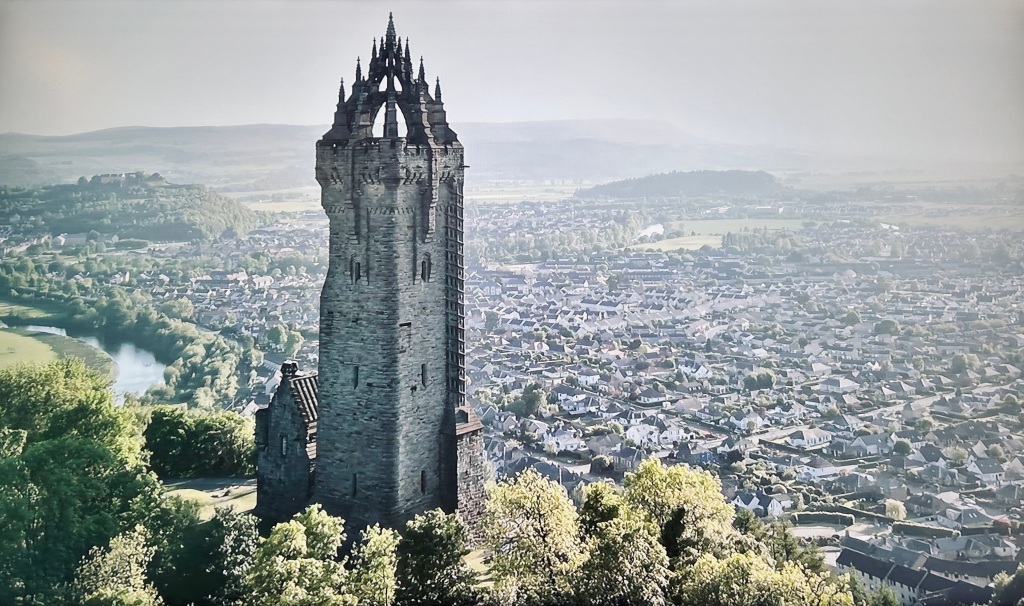
Today was a day of exploring two notable local landmarks. The National Wallace Monument dominates the skyline of Stirling. On one side of the River Forth sits the monument. On the other sits Stirling Castle. Both occupy high hills on an otherwise flat river plain.
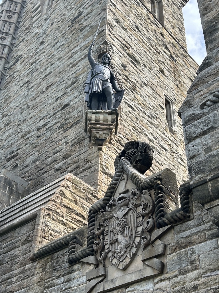
The monument sits on Abbey Craig. Craig is the name for a large outcrop of rock. It is said that William Wallace and his right hand man Andrew de Moray stood on this very spot to observe the army of King Edward 1 as it approached from Stirling Castle. You can read more here.
It was another beautiful day so having parked the car at the bottom of the craig we started the climb to the base of the tower. That got the heart and lungs working. Once we were in the tower there were another 246 steps to climb to the top 220 feet above in a winding spiral staircase for an outstanding view of the battle field and beyond. The tower is on 3 levels and each level has a room filled with history where weary legs can rest before continuing up.
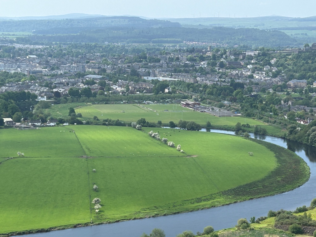
The Battle of Stirling Bridge in 1297 was a decisive victory for Wallace. The battle field is now a rugby pitch. So I suppose battle still goes on albeit more gentlemanly.
In the above picture Stirling castle lies on the hill centre right. Zooming in a little…..
The rugby pitch is the site of the battle. Stirling castle is centre right and the site of the bridge over which Edwards doomed army marched still exists today where a stone bridge stands. You may just be able to make it out behind the rugby pitch.
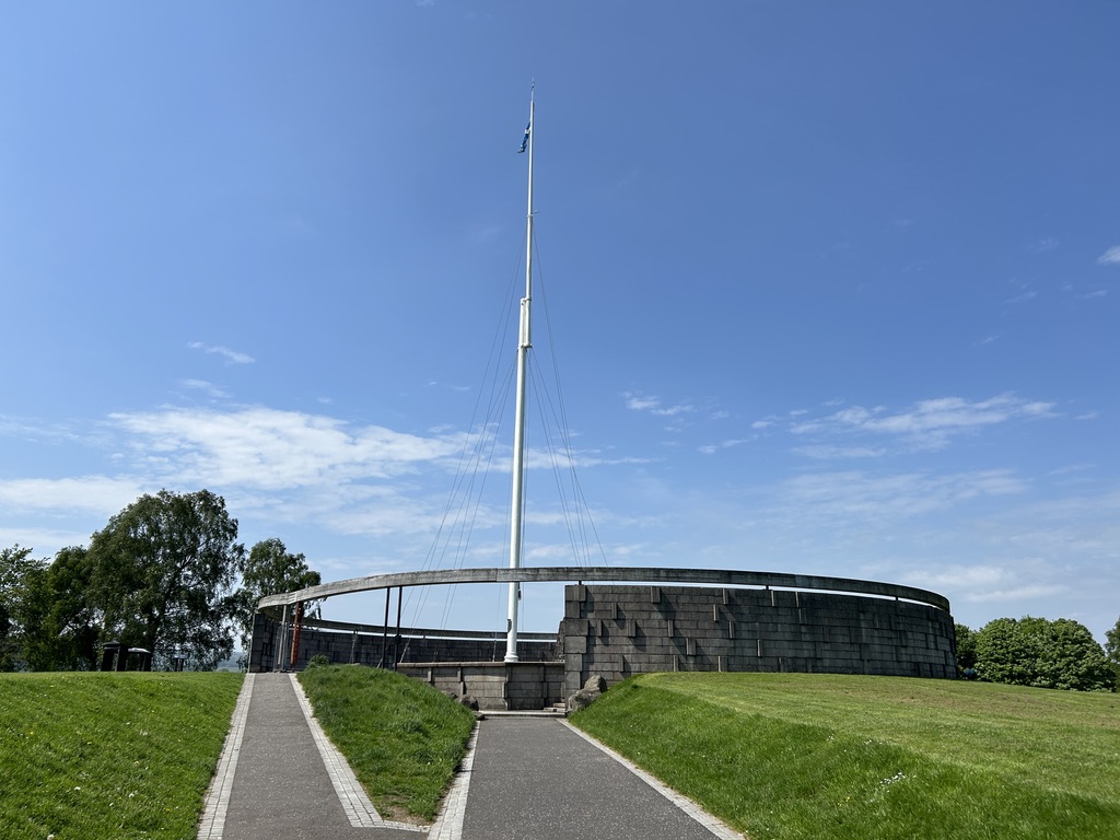
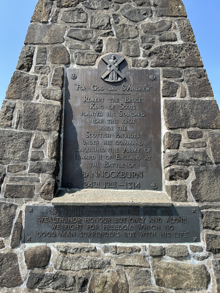
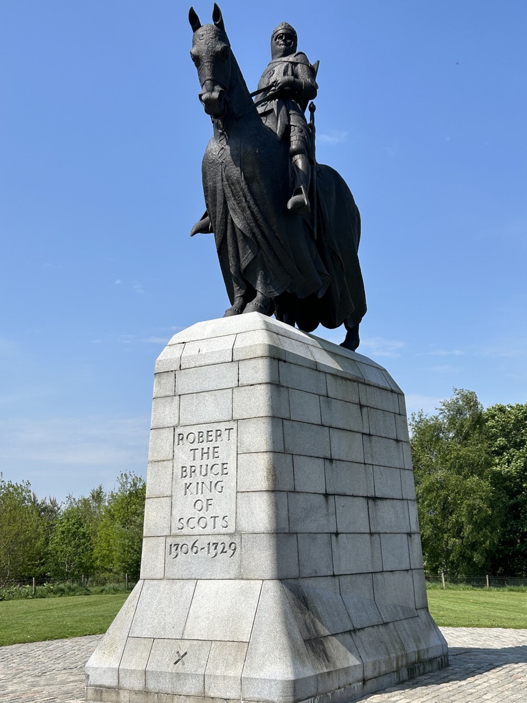
Rather like the moor at Culloden, the field at Bannockburn is hard to imagine. It is a well kept meadow now with little to remind you of the battle. Storyboards about the place point out features on the horizon showing where the advancing armies came. The large flag pole is where Robert The Bruce planted his flag having defeated the army of Edward II only 17 years after Wallace defeated Edward I. But I am pleased that we were able to fill in gaps in our knowledge of Scots history. My mother would often talk of Culloden and Bannockburn. She was a proud Scots girl and never forgot her heritage. I wished I had talked more to her on these subjects but alas it was not to be.
Tomorrow we head further south to cross the border into England. We will head to a place that Debbie and I have read much about. I last went as a small child. It is about time I returned.
The actual name of the small fishing port where we stayed for the last two nights is Findochty. It lies 3 miles east of Buckie. We stayed in a small campsite right on the sea front. I adored it. After I wrote the blog last night Debbie and I took the dog for a walk around the small harbour. I was reprimanded by Debbie for pointing out that one of the fishing boats we looked at moored to the harbour wall had a liferaft overdue for service. I know I know!
Sat on the harbour edge looking out to sea was this fellow.
I have no idea who the artist is or what it represents. But I love it. The facial expression is one of longing for the sea or perhaps waiting for someone to return from sea. Either way it really made an impression on me.
Sunset over Findochty harbour.
As we were walking back to the van I saw a lady collecting sticks off the pebble beach. She chose each piece of wood carefully. When she was finished I asked her what she was up to. Sandy who had moved here from Yorkshire makes knitted birds and perches them on the sticks she collects. She already had ideas for each stick. The dog thought the sticks were for her.
We awoke to full sun beaming into the van at 5am. I forgot to draw the blind over the sunroof window. We packed up and set off South to Stirling. Why Stirling you may ask. You will see tomorrow.
We took the scenic route as we had all day. Taking mainly B roads, (short for bloody terrible!), we made for Huntly in the middle of nowhere. This is serious farm country. Up and over hills on single track roads not often used by loons in camper vans. The road surface tested the vans springs and the ability of the fridge to keep its contents within. We had to stop as this little beastie was staring at us.
A railway viaduct in the middle of nowhere. What a beautiful piece of industrial architecture.
I could quite happily live there.
The road continued into the Cairngorm National park. We had travelled north up the west side of the park on our way to Buckie. Now we travelled south down the east side, passing Balmoral Castle. The car park was mobbed so we kept going until we reached Braemar. Again all the car parks were full so we found a spot in the car park at the Braemar highland games park. Photos on a big notice board nearby attest to the fact that the Royal Family are frequent visitors. I had been through this town before when I did a tour on my motorcycle. To me it is quintessentially Scottish. I particularly loved the look of the Fife Arms Hotel. A peek inside revealed what I would call a proper old hotel that has stood the test of time and stayed true to its traditional values.
The road south from Braemar rises up to pass the Glen Shee mountain resort, passes the most wonderfully named settlement of Spittal of Glenshee (where four Glens meet), drops down into Blairgowrie and Rattray before skirting Perth and dropping into Stirling. This stretch of road is like Arthurs Pass back in New Zealand. Beautiful, twisty and scenic with still remnants of snow on the higher peaks. You have to concentrate when driving this stretch of road.
We are here for two reasons which will become clear tomorrow. But here is a clue.
Not the caravan!
It has been another day of fabulous roads, amazing scenery and meeting lovely people. Well most of them. The roads for the most part have been reasonable. Like a lot of roads in the UK they need repairing in a lot of places. But they snake through some of the most lovely pastoral scenery around. I had no idea how remote some parts of Scotland really are.
What a day it has been. Of emotions, sunburn and filling in gaps in our knowledge of events of old.
The day dawned warm and clear with amazing blue skies. Debbie started the day off at the Buckie fishing and heritage centre.
The lady at our campsite reception recommended this as the place to go. She was armed with the knowledge that George Forbes Stevenson , her Great Grandfather was a butcher whose young son Alexander would become her Grandfather. George had a shop and we had an address. The entire family emigrated to new Zealand on the White Star Line ship Athenic departing Southampton on the 29th January 1926.
I don’t know about you but when we find out information on our ancestors it gives me a sense of wonder.
Georges shop is the property with the brown facade. It is now apartments. The building is unchanged from the day the family left it and headed for their new life in New Zealand. We filled in some gaps but the one question we wanted answered we did not manage. Why did a successful businessman in his 50s sell up and move to New Zealand? He had no known connections that we know of with New Zealand before going.
The shop would have been busy. It was right next door to what is now Buckpool and was the original harbour in Buckie. It can be seen just behind the house. It is now redundant when a new harbour was built further east. The old harbour has been filled in but the old walls remain.
We know the town prospered. I snapped this from a notice board in the town.
There was no more to be done in Buckie. It took us just a little over an hour to drive west to Culloden battlefield. On the way we chatted about what Debbie had found and what she had seen.
Culloden on the other hand is like many old battle fields around the world. It is now just a field. It is hard to imagine the horrors that took place in the very short 40 minute battle between the British Government troops and the Scottish Jacobite men. It was utter carnage and as you look out over the moor we both struggled to imagine the scene. It was a peat bog of muddy and wet heather and shrubs. In April. The site does its best to portray the scene. Stones mark the mass graves engraved with the Clan names.
You can only sit and look out at the line of red flags that marks the line of the Government troops and the blue flags marking the line of the Jacobites. It is a moving place.
We returned home thinking of the days events. There are still more questions to be answered. There always are. Tomorrow we start our journey south. There are still a few outstanding items to do though.
Day 20 was mainly a sit in the car and motor north East across Scotland. Our destination was 291 miles that took us around Glasgow to Stirling and up the west side of the Cairngorms. It was a day of two halves weather wise. We started out on cold and wet weather.
By the time we got to our lovely campsite at Findochty as few miles east of Buckie it was 22C and patchy blue skies.
We passed through parts of Scotland I had never visited. It was probably best not to have done it in a 3 metre high camper van but oh well. We passed through Callander which is lovely and I wished we had time to stop. It was a picture perfect little place. The A84 turns onto the A827 at Killin and runs along the west shore of the Majestic Loch Tay before we struck north on the B8019. I should have known by the B it was going to be narrow and twisty. Thus it was but oh the views.
And the logging trucks hurtling the other way. I still have both wing mirrors. I was too kind to a lot of cars coming the other way trying to get over as much as possible on my side of the road occasionally flinging mud up under my nearside wheels. The cars coming the other way seemed to make no attempt to slow down or move over so I adopted the hard nasty approach and held my line. I am simply too nice. The van is now covered in mud, dirt and dead flies. We continued. The village of Fortingall could be lifted straight from the Cotswolds.
The van is 3.2 metres high at the tv aerial. I winced passing under this bridge but no nasty scraping noises.
After 7 ½ hours we arrived at our camp for the next two nights. Right outside the campsite is the Red Admiral pub. It would have been desperately rude to travel the best part of 300 miles and not support a local business. So we did. And I was glad of it. The dust of the road was heavy in the throat. A cold pint of local brew was just what the doctor ordered.
Tomorrow will be a special day. Debbies Great Grandfather and his son, her Grandfather both came from Buckie and we are going to see what we can find. In addition we will visit Culloden battlefield.